meatheadhikes

- https://www.instagram.com/meatheadhikes/
- United States
- 6 Followers
- Following
Fitness professional, backpacking amateur, always looking for a new challenge to get me outside my comfort zone #pct2017


Copy the content below and paste it in the page in which you would like this embedded. Change the width value below as necessary.
Mon May 1, 2017 @ 22:02
- Meathead Hikes The Pacific Crest Trail
- Appalachian trail
"How do you train for hiking 2650 miles on the Pacific Crest Trail?" A lot of people have asked me this, including many of my colleagues in the fitness industry.
Many of my fitness expert friends were all too eager to give me some (rather opinionated, not to mention unsolicited) advice on all the stuff I should be doing in the gym to prepare to hike from Mexico to Canada ... farmer's walks, stepmill with a weighted vest on, walking lunges for an hour a day, core training, core training and more core training, yoga (including on the trail), and a lot more... (nevermind they had never hiked a day in their lives, let alone thru-hiked).
Others, including highly skilled and knowledgable trainers, had no idea how you'd prepare for a trek like this. They never had a client who was trying to get ready for something like this.
I think the answer is simple. You follow the same two primary principles of conditioning that apply to any sports training or fitness endeavor:
- Specificity
- Progression.
If I'm going to have to hike 20 to 30 miles a day carrying 20 to 30 pounds on my back over rough and steep terrain to make it through this 2650 mile trail, the best way to train is not to do a bunch of "functional" stuff in a gym, the best way to train is to go hike 20-30 miles a day carrying 20 to 30 pounds on my back through rough and steep terrain, right? That's the principle of specificity, isn't it?
In fact, the ultimate (specific) way to train would be to go hike on the Pacific Crest Trail itself, with the same pack I'll be hiking it with, in the same conditions I'll be hiking in (including desert heat and or snow). But since I live on the east coast, the next best thing is the Appalachian trail, so that's exactly what I've been doing.
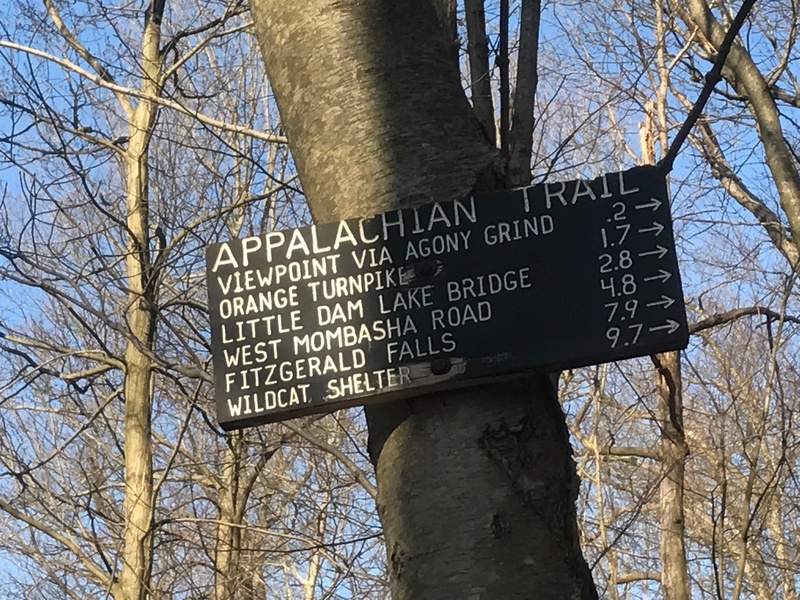
In the past month and a half, I've section hiked almost all of the NY and NJ part of the Appalachian trail (pictured: when your hike starts with "Agony Grind" you know it's going to be a good one!)
Now, don't get me wrong, I'm the biggest advocate of resistance training ("pumping iron") you will ever meet! I started lifting weights in my parent's garage when I was 14 years old and have never missed over a week of planned workouts in the 34 years since! (including 28 bodybuilding competitions between 1989 and 2005).
I believe strength training and other work you do in the gym is only going to help a hiker, not only to perform better but also to avoid injury. But I don't think any specific exercises you do in the gym will be a substitute for time on the trail. The best way to train for hiking is hiking.
Principle two would suggest: Don't try to start with 20-30 miles a day with a 20-30 pound pack or you are going to be hurting, or even cause a serious injury (possibly one that is hike-ending). I've been applying this training principle by progressively building up the distance, packweight and elevation gain.
In the past week I finally built up to "26 with 26" - 26 miles with total pack weight of 26 lbs (combined with over 4000 feet elevation gain/loss). That puts me right on schedule because my goal for the Pacific Crest Trail is a "marathon a day" and the pct sure isn't level (490,000 feet of total gain and loss, according to the most recent data from the pcta.org website)
As I write this, it's Just 3 weeks until I start my 2650 mile hike from the Mexican Border to Canada, and thanks to my training I feel 100% prepared physically to cover the distance and elevation. The only thing I haven't trained for is the desert heat and the snow.
Maybe even more important than the purely physical readiness is that being out on the trails for shakedown hikes has given me the chance to test out all my gear including shoes, socks, pack, shelter, sleeping system and everything else I have to carry with me. Plus I've experienced, cold, heat, rain, mud, rocks, climbing, descending and what it feels like to trudge through these conditions from sunrise to sunset.
By the way, go ahead and tell me it's not going to happen because I'm going to be too tired, (like everyone else on the hiker forums and facebook groups has told me), but I still plan to lift during this trek. I might be the only person who has ever done it... but that will be the subject of another post...
Sat Apr 22, 2017 @ 08:05
- Meathead Hikes The Pacific Crest Trail
- “Hiking 2650 Miles Is Crazy!" So Why I Am I Doing It?
Why walk 2650 miles? Almost every Pacific Crest Trail (PCT) thru-hiker is asked this question, usually followed by an expletive-filled statement of astonishment or incredulity like, “That’s *** crazy!” A barrage of 20 more questions comes next, including doozies like, “Aren’t you afraid of being eaten by bears?” Or, "Are you bringing a gun?"
Hikers endure these inquisitions so many times, they usually get pretty good at rattling off a list of reasons, explaining and justifying their decision (even though most non-hikers will never understand).
I have many motivations and reasons as well, and explaining the details might make another interesting post. But I thought a good way to open my journal documenting this trek would be to start from the beginning - who am I, where am I from, and what inspired me to take on this journey? What put thru-hiking the PCT on my radar in the first place?
The short answer is that I fell in love with the mountains of California, especially the Sierra Nevada, and the adventure of exploring them. Those snow-capped peaks left a stronger impression on me than any place I have ever visited. After a summer living in California in 2016, I couldn’t wait to go back and see more - to see it all! I also wanted a completely new physical (fitness) challenge - something far out of my comfort zone.
Most of my journals during the hike will be short, because I won’t have a lot of down time (I’m starting late, on May 22nd. The majority of thru-hikers start in April, so with my shorter window, I need to put in full days on my feet). But since I have time to write now, still a month before I take my first Northbound steps from the Mexican border, I thought I’d use the opportunity to fill in the whole back story first, so this will probably be my longest post.
I guess it shouldn’t be surprising that I’ve always felt drawn to California, considering I was born in Santa Clara in 1968. That’s the same year the PCT was designated as a national scenic trail - it’s much newer and less known than the Appalachian Trail in the East (which was started in 1923 and completed in 1937).
I have many fond memories of the West coast, because my parents took my brother and I to the Santa Cruz county beaches often, as well as to local, state and national parks. Even things I don’t recall actually experiencing because I was too young, I do remember today from my dad’s slide shows of all the places we visited, like Pinnacles, Yosemite, Lassen and Crater Lake.
After moving East in 1978 - to the Boston area, then Northeast Pennsylvania and finally New Jersey near New York City, and living there ever since, I often dreamt about returning to visit the West coast. I finally did, but not until 2000, when I attended a seminar for entrepreneurs (I had recently started a small fitness business at the time).
The event was held in Marin county, in an affluent bayside town called Tiburon, just North of the Golden Gate bridge. After the seminar, I had a few personal days blocked off so I visited the city of San Francisco and explored Golden Gate National Recreational Area, the Marin Headlands, Mount Tamalpais State Park and the Point Reyes National Seashore. The scenery was beautiful and it was my first taste of hiking the parks as an adult. I loved it! The seeds had been planted.
I’ve been California dreaming even since. Though I never did move back, the California coast, especially the Bay area, became my favorite and most frequent vacation spot and I lost count of the number of visits I made over the next 15 years.
Mostly though, I stuck to the coast - Marin, Sonoma, San Francisco, Santa Cruz, Monterey, Carmel and one of the big highlights - A coastal highway one road trip through Big Sur, from the Golden Gate Bridge to Los Angeles - one of the best scenic drives in the world. The coast was breathtaking, but I didn’t see the big California mountains for the first time until 2016.
I appreciate the Northeast and definitely enjoy the perks of living next to one of the greatest cities in the world - New York - but it’s loud and crowded and I grew tired of being there all the time. I missed the scenery, solitude and silence in the West.
At this point, my fitness business and writing endeavors were going well enough that I’d earned a certain degree of time, financial and location freedom (my business had moved from training people in the gym to coaching people online - and I knew I could do that anywhere in the world with nothing but a laptop).
I always told my friends I was going to move, but I wasn’t prepared to pack all my belongings and re-settle in California yet. So I decided to do the next best thing, which I considered an experiment in “lifestyle design.” Part of the year I would live in New Jersey. Part of the year I would live near San Francisco.
I packed a couple bags, hopped in my car, and took the bucket list road trip many people dream about. It was an amazing moment as I drove across the bay on the San Rafael bridge, with the sun setting and the Pacific fog rolling over the hilltops, realizing I had just driven 3000 miles in three days.
I rented a house in Mill Valley, a little town nestled in the redwoods at the base of Mount Tamalpais, only a short hike to Muir woods, Muir beach, the Marin Headlands and the top of Tam. A mecca for mountain bikers, runners and hikers, there were hundreds of miles of trails literally out my back door. I had a view of the Richardson Bay, Angel Island and the Bay Bridge from my living room, but I didn’t spend much time inside.
I spent the whole summer hiking, often to the beaches, and when I’d already traversed all the local trails, I started road tripping to find new ones. South to the Santa Cruz Mountains, on long hikes in Big Basin Redwoods State Park and then North to Sonoma, Mendocino and Humboldt Counties, to the Big Old Growth trees of Redwood National Park. The hike from Prairie Creek Redwoods headquarters to “Jurassic” Fern Canyon and the Golden Bluffs Beach and back was especially memorable, as was staying in the quaint village of Trinidad.
Looking at the map, I saw I was so close to Oregon, I was tempted to keep driving North, but instead, chose to drive East through the mountains on the winding Trinity Scenic Byway. When I hit Interstate 5, I turned north and stayed for three days in the Town of Mount Shasta.
From my stack of California hiking books, I found several places I put high on my list to visit. Up Mount Shasta of course, was first. Although I wasn’t ready to attempt a summit, a day hike at 8,000 feet in Panther Meadows, to Grey Butte, and the Old Ski Bowl area offered up jaw-dropping views. Shasta is massive, and standing on it after seeing it from a hundred miles away is an awesome feeling.
Next to Shasta is Black Butte, a smaller satellite volcano, but one you can’t miss because it towers right over the Interstate. It’s so steep and rocky it look’s unclimbable at first, but when I discovered there was a trail to the top, that hike was next on my list for day two. On the summit, at the crumbling foundations of an old fire tower, you get one of the best close-up views of Shasta you will ever see. A trip to lake Siskiyou was a great way to spend the rest of the hot, sunny afternoon, offering up even more vistas of Shasta over the water.
On day three, I hiked up to Castle Dome at Castle Crags State Park (a great day hike if you’re in the area). In the trail guidebooks I’d been reading all summer, I kept coming across “The Pacific Crest Trail” (PCT). Those hiking books were the first place I heard of it. Walking up to Castle Dome, there it was - the first time I saw the PCT in person.
It was still early - only mid-morning - so I returned to my car at the main park entrance to get some food, tossed some snacks and water in my daypack, double checked the map, and headed back up the PCT trailhead. I planned a 10 mile out and back which I figured I could do before sunset. I’d had done 20 mile day hikes before, but I didn’t really know what I was getting into that day.
A few hours later, around mid-day, the temperature climbed to a sweltering 104 degrees. The slog up the backside of Castle Crags was at least a few thousand feet of elevation gain and mostly exposed, with little shade. By the time I turned around at mile 10, I realized how poorly I had planned my water supply. I had no water filter (didn’t know about that yet), but the creeks were dry anyway. I realized how dehydrated I was when I tried to say hello back to another friendly hiker, but I had lost my voice.
Despite my ignorance about proper hydration, checking the weather report and considering exposure, which lead to a very uncomfortable few hours, I loved the trail and already wanted more. Altogether, I covered a marathon distance - 26 miles - that day.
Mount Lassen Volcanic National Park was my next stop. On the way, I stopped at Burney Falls. Unlike the dry seasonal falls (Burstare) I passed on the PCT near Castle Crags, 129-foot high Burney was bursting with millions of gallons pouring over and through the rocks, the cold spray making for some nice air conditioning. As I finished the short falls loop, there it was again - the PCT. The sign said, “Mexico 1418 miles. Canada 1232 miles.”
I sauntered a short way on the PCT, and looking at those ridiculous distances, I was intrigued with the idea of what it would be like to just keep walking. Alas, I had Lassen on the day’s agenda, so I turned around, left Burney and drove toward that next Volcano on the horizon.
When I arrived in Lassen I took the scenic loop drive around the whole park, stopping off at all the points of interest. Three short hikes in one day: Around Lake Manzanita, with Lassen perfectly reflecting in the water, up to Chaos Crags, and then to the thermals and boiling mudpots of Bumpass Hell. Looking at the trail maps, there again I saw the PCT winding through the park past all this unique geology.
Thirty miles south is the town of Chester, where I stayed for the night. Turns out, this is a popular PCT hiker town, with the trailhead just a few miles from main street. It’s a small town, but has all the amenities anyone would need - full grocery store, restaurants, pizza place, Mexican restaurant, Chinese restaurant, even a gym… walking distance from the motel.
For day two in the Lassen area, I drove back up to the park first thing in the morning to summit Mount Lassen. The day before, thunderstorms were threatening around 1 pm and there were scattered rain showers when I was walking the Bumpass boardwalks in the afternoon. I’d made a note of the lightning warnings and planned to head up Lassen by 7 am, when the chances of storms are less frequent.
The Lassen summit trail is a nicely-manicured and well-graded path that starts at 8500 feet and climbs to 10457 - just under 2000 feet of gain in about 2.3 miles. The park brochure says to allow 3 to 5 hours. It was a hot August in a dry year, with no snow on the trail - only on the summit and down a few gullies. I was up and down in just over two hours, though I enjoyed some time on top to take in the views.
With most of the day ahead of me, it was up to the Old Station area and the Subway Cave lava tube. Then, to the Hat Creek Rim overlook. Looking at my maps, again I kept seeing references to the PCT. I would later hear about this notorious, hot waterless stretch when I started reading about trekkers who cross the area on a thru hike (and I was already making note when I saw a water fountain). Everywhere I looked on this trip, I kept coming across the PCT - seeing signs in person, seeing it on the maps - it was like the PCT was calling to me.
My last destination through Lassen Park was to the Fantastic Lava Beds and the Cinder Cone. The landscape is surreal. It feels like you’re on another planet. Lassen is one of the hidden gems of the National Park System - I highly recommend it. I encountered no crowds like I did later in Yosemite, and enjoyed long stretches of complete solitude.
It was back to San Francisco at that point, and the summer was coming to a close. I spent most of my final weeks by the bay on my laptop, catching up on work, but it wasn’t such a hardship doing it while sitting in the coffee shops of Sausalito or in the town square of Mill Valley. When my work was done, I spent every spare minute researching California hiking, and the Pacific Crest Trail… plotting my return.
I discovered books about the PCT, found personal vlogs on You Tube and many documentaries. One of my favorites was called, The Pacific Crest Trail: As It Happens, and I watched it many times. It was filmed in 2011, which depicted the conditions in the high elevations during the last big snow year. This inspired me to the point that I was seriously thinking about thru-hiking, even though I had never backpacked a day in my life. Between June and September, I had hiked almost 1000 miles in California - but it was all day hiking - not a single overnight. I didn’t even know how to filter water or pitch a tent.
My plan for that first summer in California was to drive West fast on I-80 and drive East slow - on route 66 - stopping to see all the major landmarks. But instead of my original plan to take the coastal Pacific highway again to Los Angeles and then take the Mother Road back to its Illinois terminus, I decided to cut across California first and pick up 66 in Arizona. From all my reading and video watching, I had learned about the Sierra Nevada mountains and I wanted to go.
I almost skipped Yosemite, fearing hordes of tourists, and what a mistake that would have been - it was spectacular. I got there the day after Labor Day weekend, and while Yosemite Valley near the lodge and visitor center still was still packed, the rangers told me this was nothing compared to the record crowds two days before.
Plus, it was easy to get off the beaten path. I took the Upper Yosemite Falls trail and passed at least a dozen people on the lower portion, but when I reached the (unfortunately dry) upper falls, and started heading toward the top of El Capitan, I didn’t pass another soul. I’m not a climber and can’t imagine the feeling of the people who get to stand on top of that monolith after climbing it, 3000 feet above the valley floor, but I did get to enjoy the same view, and had it all to myself.
That was a strenuous hike, but at this point, I was already in good hiking shape and I was choosing long, rocky and steep hikes on purpose because Mount Whitney was on my bucket list. During my few days in Yosemite I also strolled around the valley, drove up to Glacier Point and took another hike to Cloud’s Rest, which rewards you with one of the best views in the Park. I stopped at Tuolumne meadows and yet again - there was the PCT as well as the John Muir Trail (JMT).
I enjoyed a late lunch from the shores of pristine Tenaya Lake, looking up at 13,000 foot peaks, and left Yosemite to the West through Tioga Pass, yet another epic drive. I had a chance to briefly stroll around Mono Lake, and then hit my first stretch of highway 395 as the sun set over the Eastern Sierra. My next stop: Mammoth Lakes. I didn’t know it at the time, but my hike near Mammoth would be my favorite day of the summer of 2016 and my new-found favorite place: The Ansel Adams Wilderness.
A quick drive from Mammoth Village to Devil’s Postpile National monument was the start of my day hike. Using a National Geographic map of The JMT, I was able to see mileage between waypoints and junctions and I created a 26 mile loop around the lakes near the jagged peaks of the Minarets. Most people would do this as a two or three day backpacking trip, but I was sure I could do it in a day if I started early.
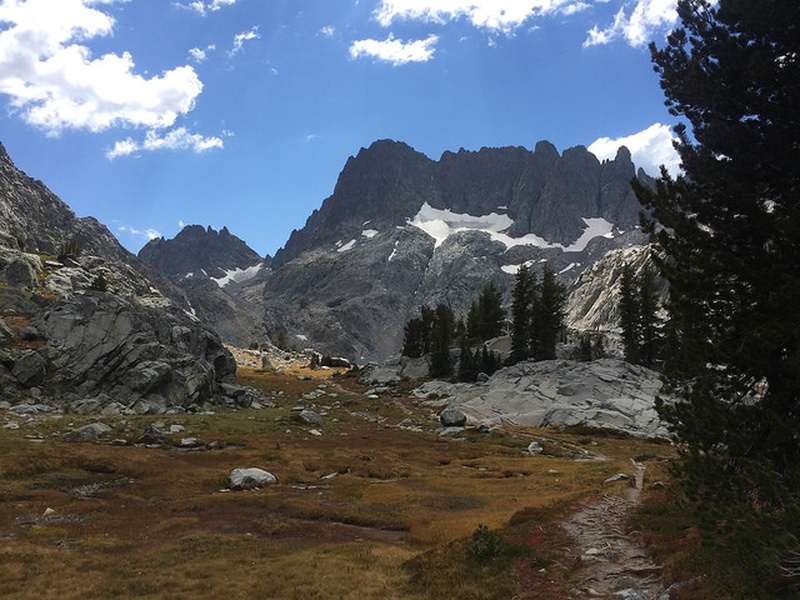
The loop was 16 miles on the Minaret creek trail, to Minaret Lake, then up and over to Cecile Lake, then down a steep chute (no trail, just rocks) to Iceberg lake, then the trail emerged again, leading down to Ediza Lake and finally Shadow Lake, and 10 miles back on the JMT. There again, I passed the PCT trailhead, snapping a shot of the sign as another reminder of what was now my goal for next year.
This Minaret Lake loop revealed some of the most spectacular natural beauty I had ever seen - views that most people will never see, because the area is not accessible without a very long walk. If you ask almost anyone - including locals and seasoned explorers, they’ll confirm that the Ansel Adams Wilderness is some of the best the Sierra has to offer. It’s no wonder these landscapes became the subject of famous photographers. I wish I had spent more time here - another all-day loop up to Thousand Island Lake was also on my list, but I told myself, “I’ll be back.” It was onward to Mount Whitney.
Lone Pine California is the small town closest to the Whitney Portal, an area that Hollywood made famous as the site of hundreds of Westerns and other movies. Since Whitney is the highest peak in the contiguous USA at 14,508 feet, it’s a bucket list item for all kinds of people from weekend warriors to peak baggers to serious climbers. Permits are strictly limited to control the crowds and reduce the impact on the environment. As a result, they are usually all snatched up early in the year during the lottery.
You can however, show up in person in Lone Pine and ask if there are any cancellations or remaining spots open. Most people camp on the mountain and the overnight permits allowing you to do that appear harder to come by. Day hiking Whitney is more of a challenge due to the potential for altitude sickness and the strenuous nature of the hike (6,000 feet of elevation gain and 22 miles roundtrip). That means a better chance at scoring a next day walk-in permit, especially during the week and if you’re solo. I walked into the Eastern Sierra Interagency visitor center on a Sunday afternoon, September 11th, and got the permit for Monday the 12th.
I asked the ranger what is a quick but reasonable time for someone who is in shape. He said most people take a lot longer, but a fit hiker could do it in 12 hours. That sounded about right to me based on my previous efforts. My 26 mile loop near Mammoth covered 4000 feet of elevation gain and loss with very slow rock scrambling in a couple spots and that took 12 hours on the button.
I got up at 3 am, figuring a 4 am start time would be perfect. I filled up a light daypack with water, a couple meals and plenty of snacks, threw in a couple layers and a headlamp, and drove up from Lone Pine (elevation 3727 feet) to the portal (elevation 8500 feet) in the dark. It was pitch black and this was the first time I had ever used a headlamp. It was a strange, disorienting feeling at first.
As I started up the Whitney trail, I could see parades of headlamps above and below me, so I was solo, but not alone. I turned off my headlamp for a minute and looked up at the sky. You’ll never see stars like that in the city with all the light pollution. It’s an incredible sight. The next “mind blown” moment was when the pre dawn light first appeared over the mountain range to the East, and then the sun came up, casting it’s alpenglow on the rocks to the West above me. The first two hours went by fast and I moved fast.
About three more hours after sunrise, after zig-zagging up the infamous 99 switchbacks, I reached “Trail Crest,” The point where you can first see over the mountain to the West into Sequoia and Kings Canyon National Park, and also the place where the JMT meets the Whitney Portal trail. From there the trail gets more rocky and rugged for the final 1.9 miles to the highest peak in the lower 48 states. At this junction, I was not only greeted with hikers coming up the other side, but also with a blast of freezing wind in my face. Another warm layer and hat went on. I could have used a balaclava.
This is also where the PCT hikers climb up Mount Whitney from the West. Crabtree Meadows below, at 11,000 feet, is a popular campsite for staging an early next-day climb. That makes a Whitney Summit a considerably easier (side) trip from the main PCT trail, due to PCT hikers already being acclimatized and having less elevation to climb. I knew this because by this point, in September 2016, I had studied everything I could about the PCT. I wasn’t even on the summit yet, and was thinking of hiking Whitney again in 2017, only from the other side.
Thru hikers (JMT) were leaving their packs at trail crest, and I quickly discovered why - the air has one third less oxygen at that elevation - 13,600 feet. There’s less than 2 miles to go from trail crest, but it felt like the longest 2 miles I have ever traveled and I wasn’t even carrying much weight. I knew I was in good shape, and was on pace to make it up and down in much less than 12 hours, but at that elevation, I was really feeling the effects of altitude and it cut my pace in half for that final stretch.
Long, slow breaths and the icy wind were the sensations I noticed the most. At least my legs felt strong. The panorama from trail crest and over the final miles was incredible. When snow dots the landscape, just a little, I find the mountain view is all the more spectacular, but it was the second week of September, after a drought year. It was barren rock everywhere - just a few tiny patches of snow in spots where the sun doesn’t shine much. There were also a few patches of ice, which confirmed my suspicion that the temperature was below freezing at night and wasn’t out of the 30s in the morning. With windchill it felt like 15 or 20 degrees. I realized I didn’t have very good gloves because my hands were getting numb. Down below in Lone Pine it was 80 degrees.
Most of the Whitney Portal Trail is a well-graded and clear path, making it a long steep hike in the late summer, not mountaineering. The last leg to the summit however, is a lot more rock, including some scrambling over boulders. There was no snow on that day, but it can snow up there any time of the year. The peak looked like nothing but a big pile of rocks. At the top of this giant rock pile, you see it - the Smithsonian Shelter, built over 100 years ago - and that’s when you know you’ve made it.
I lingered only long enough wolf down a snack and snap some pictures. I was cold and uncomfortable, including the headache I got as soon as I reached the summit. Considering I day hiked up from the valley floor, I was at the same time happy that was the worst of it, along with a little shortness of breath over 13,000 feet. I spoke to two people earlier who said they had altitude sickness and couldn’t summit. I made haste on the way down, being mindful of the sheer drop-offs on either side of the trail where it narrowed and opened up to “windows” which expose steep chutes plunging a couple thousand feet down. At the end, it was time for a celebratory gigantic double cheeseburger and Sierra Nevada Pale Ale at the Whitney Portal Store.
My time in California and the Sierra was over, though my trip wasn’t quite finished yet. I spent some great time in Death Valley - just a short hop from Mount Whitney. (By summiting Whitney and then driving to Death Valley, you can go from the highest point to the lowest point in the country in the same day - 14,508 feet to 282 feet below sea level). I also had a great hike in the Grand Canyon from the South Rim to the Colorado River and Back up in half a day (wondering what it would be like to go from rim to rim to rim in a day next time). Then I enjoyed a full week driving back east, another 3000 miles, on old Route 66, before re-joining the last (uninspiring) stretch where I started - on route 80 back through Indiana, Ohio and Pennsylvania, into New Jersey.
The memories of 6,000 miles road tripping across the country, 2,000 miles of scenic drives through California, and day hiking almost 1000 miles will last a lifetime. But I knew that the summer of 2016 was just the beginning - it was one of many trips of a lifetime. My time in the West, especially in the mountains of California, inspired me not only to go back, but to take on an even greater adventure.
The new challenge: Hiking in a continuous path from the Border of Mexico to Canada on the PCT. The PCT called to me last year, and now I’m going.
PCT class of 2017 thru hikers have been watching the weather all winter as record snowfalls hit The High Sierra. The area above Mammoth where I hiked on visible paths of dirt last September is buried under 20 or 30 feet of snow and new snow is still falling in many places. 2017 has now been confirmed as the highest snow year in the last decade. Thru hikers entering the high Sierra before mid June are being warned that they are going to have a real challenge getting through the high country and over the mountain passes that gave others relatively worry-free passage last year.
Many people don’t make it to Canada, or even through the Sierra, when conditions are perfect. The failure rate will be higher this year and some people may get into serious trouble. But with a little caution, proper preparation and the right gear (clothing, ice axe, and spikes or crampons), hundreds of thru hikers will do it.
I’ve been saying I’m going to “attempt” to hike the entire trail from the wall at the Mexican border to the monument in Canada, and some friends who know me as an optimist reply, “Don’t you mean you’re going to do it, not just try it?” The truth is a lot of things could happen along the way, and I don’t know If I’m going to make it either; I only know I’m going to start and get as far as I can, and that challenging conditions will simply make what is already an adventure of a lifetime all the more rewarding with every comfort zone broken and each obstacle overcome.
Pictured: Ansel Adams Wilderness between Iceberg Lake and Ediza lake, Sierra Nevada Mountains, near Mammoth Lakes, California. September 2016
Meathead Hikes The Pacific Crest Trail
- updated May 1, 2017
- 2 Entries
- 31 Followers
- Pacific Crest Trail (PCT)
- Backpacking, Hiking
Outsideways Blog
Journal Spotlight: Kayaking Around the Eye of Quebec

One of our members, will soon be circumnavigating one of the coolest lakes in Quebec by kayak