Day 2, July 11th: Just before Lyell Fork to Garnet Lake. 11 miles
(Note: these entries are from my trip last summer. I am writing them after-the-fact)
We wake up early and head out, but not early by PCTer standards as attested to by their steady passing, trekking poles clicking against rocks. The trail is forested, and joins the Tuolumne again as we pass through patches of Red Heather with its bright pink flowers and bristly, pine-needle-esque stalks poking up from the pine duff. We cross the river on a wood footbridge and begin rising out of the trees. The trail winds around small ridges of granite and alpine green, crossing more water, until we come out into what might be Maclure Creek. The creek is wide here, creating a tarn further up into the meadow. People are waiting to ford the river, fiddling with water shoes. After agonizing over the chore of taking my gaiters and shoes off, I step into the water. At first it is just cold, but as I stride in to my calves it begins to numb. I hobble over the loose rocks on the bottom, their smooth surfaces painful on my cold feet, and clamber up onto the soft trail.
I walk barefoot for a while to let my feet dry, when suddenly the mosquitos hit me. Why weren't they on the other side of the river? I find my headnet and struggle to put my toe socks on damp feet. Fortunately, the trail climbs quickly out of the narrow meadow, water rivulets sliding across the rough granite steps. Within five minutes I can put my headnet away. That wasn't so bad, I tell myself.
I'm fast on the uphill and get ahead of my mom. I hike near another guy who is waiting for his hiking partner to catch up. He's not American, but I can't place his accent from the couple of short exchanges we have. It sounds very familiar.
We have to cross a small snowfield as we climb up to Donahue Pass. The snow is still hard so it's slippery, and I have to screw my eyes shut against the light bouncing off of it. I probably should have brought sunglasses, even though I don't like them. I reach the top of Donahue and look back the way we came. Lyell Canyon is a small, bright strip of green between the rows of mountains. My mom comes and we pause to look at the clear pools of water that sit by the side of the trail. We say hello to the female ranger who is checking permits and head down the other side with a bunch of other hikers.
The mosquitos come. They come slowly so you think you can manage it, until suddenly you can't.
The response of the other hikers is to hike faster, and they quickly disappear down the trail until it is just me and my mom. While I'm fast on the uphill, I'm pretty slow on the downhill, where I'm careful to not slip or pound my feet or knees. For a while I try to outhike the mosquitos, try to move fast enough that they can't land, but they still buzz around my head in a cloud and get into my headnet. I hit my trekking poles against my ankles, swat at my legs and wrists. My headnet is hot and is making it hard to breath. Finally I stop and find my windpants, tugging them on over my shoes. Now the only thing that isn't covered are my hands, and even though I have to go slow not to overheat, it suddenly becomes almost bearable. I still want to melt into a puddle, but not nearly as fervently.
It's gorgeous on this side of the pass, bright green tussocks and clumps of small, twisted pine, with pools of mosquito-incubating water riddling it all like Orthanc after the Ents. I feel bad that I've missed it with the mosquitos, but oh well.
The trail descends from the mosquito swamplands and suddenly there is a breeze. I take my headnet off and pause to breath and wait for my mom to catch up. A PCTer comes up and I lament to her about the mosquitos. "What mosquitos?" she asks. "The mosquitos aren't bad at all."
"They're pretty bad," I say, lamely, and she hikes on.
The trail immediately becomes arid and the soil sandy as it descends to what the map euphemistically calls "Island Pass," and I imagine that the PCTer learned the truth of my words. We meet an awesome PCTer named Smiles when we are filtering water, who hiked the JMT solo when she was my age. We talk about hiking the PCT solo and young and she says go for it. She is definitely my favorite thru-hiker we have met, very positive and friendly.
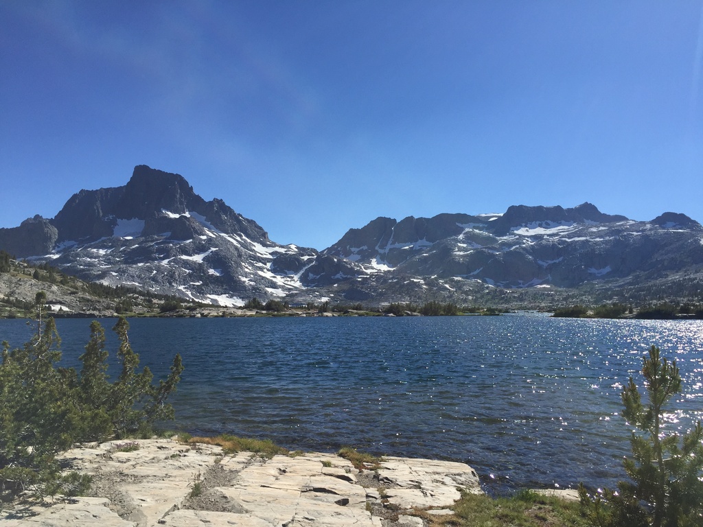
We pause at Thousand Island Lakes, which is very pretty but hardly the golden child of the JMT like people claim (at least that's what I think). The sun is getting low as we pass Ruby Lake, with dark cliffs plunging into the clear water, desolate scree piles hugging the base. We only stop for a moment, but Ruby Lake is one of the most understated and dramatic lakes that I will see on the trip.
We set up camp at Garnet Lake, with the classic view of Banner and Ritter Peaks reflecting off of the surface. It's 14 miles to Red's Meadow from here, all downhill, and we plan on eating real food for dinner tomorrow. My hands got a little burned, and like everyone else I've noticed that I'm getting tanner on my right side faster than on my left, since we're walking south.


Comments
My thoughts on water crossings with shoes is to just walk on through. Assuming you have lightweight quick-dry shoes, they will dry soon enough on their own. I think the tradition of removing footwear came from the days of heavy leather boots, where getting those suckers wet meant they would stay wet for the rest of your trip.
@toesalad Yah, they pretty much never came off for water after that...
You must login before you can comment.