John Muir Trail (JMT)

- United States
- 2 Followers
The John Muir Trail (JMT) is a long-distance hiking trail in the Sierra Nevada mountain range of California. It passes through Yosemite, Kings Canyon and Sequoia National Parks. The trail starts at Happy Isles in Yosemite Valley and ends on the summit of Mount Whitney for a length is 210.4 miles (338.6 km).


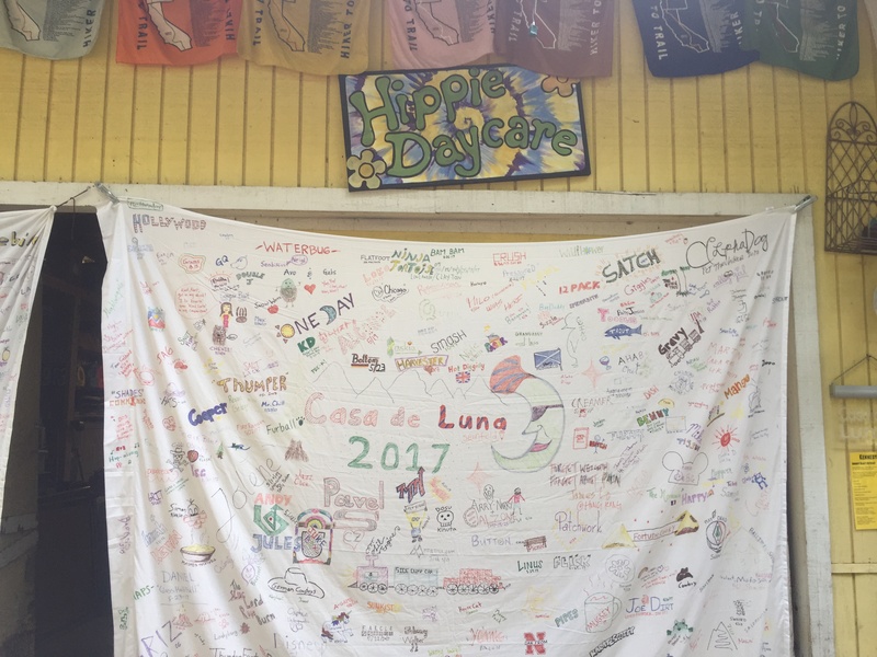
My name is in there somewhere, below the moon.

Day 6, July 15th: Pocket Meadow to Vermilion Valley Resort. 3.6 miles. (Note: these entries are from my trip last summer. I am writing them after-the-fact)
Cowboy camping is great, although I have a fear of rolling off my groundsheet and getting my sleeping bag covered in dust or mud. My nose is cold from poking out of the cinched-up hood. We pack up and eat our random things for breakfast, then leave. We're both in a good mood. It's still smoky, and the flowers are incredible, but we can't stop to appreciate them. Will we catch the ferry? The trail switchbacks down through nodding Black-Eyed Susans and hanging orange Tiger Lilies, hot pink newberryiae Penstemon, and everything besides.
We're going to miss the ferry time if it's actually at 8, but we still keep going in case the info we have is wrong or if the ferry waits. If not, we can always have a meal at the lake and walk the flat 8 ish miles to VVR today. The trail splits off to VVR through a thick and meadowy forest. The path becomes narrow and dense grasses brush our legs, a few mosquitos find us and half-heartedly follow.
The trail disappears at the edge of the lake where a sign with the ferry times is posted on a tree. The time we had is wrong, it's actually 9:45, so we'll catch the ferry after all! The lakeshore is cut by small ridges of granite filled in between with water. We make our way across one of the ridges to the upside-down orange Home Depot bucket sitting on a metal post that marks where the ferry will land. I set my pack down against a granite ledge and unfurl my accordion foam pad. I'm about to break open some snacks for an early lunch when the ferry boat comes up, early, and scrapes onto the shore the next granite ridge over. I shove my things back in and we scramble over the rocks. We get in with a PCTer couple. It's a big boat, and we lay our packs and trekking poles down the middle length-wise with plenty of leg room to spare. We pull out into the middle of the lake and idle, waiting for more hikers to appear. The engine is too loud for conversation and the air is tainted with exhaust. After half an hour we start heading down the lake towards VVR.
The wind roars by and forces me to squint and keep my head down. Apparently there's AT&T service in the middle of the lake, but we have Verizon. The boat pulls up to a high dirt bank, engine puttering, and we slide up onto it with a crunch. Paddle boats and canoes and random junk lines the bank. We step out and skirt around a stack of old windows. The man gives us a tour, pointing out the bathrooms and laundry, explaining the honor-pay system. My mom gives me a mischievious sideways look as we walk past the tent cabins, and I shake my head at her, grinning. We set up our tents in the camping grove, leaving our packs inside, and go to the store to set up our tab and get our free drink. There are more PCTers here than I've seen in a while, as we've been hitting the tail end of the herd. There are so many people around and things to do! We watch as a helicopter dips down to the lake with a gigantic bucket, fills it with water, and then flies to the fire that's by the side of the lake. Because of the fire, they won't be serving lunch, and we sit around talking to people for 6 hours, waiting for dinner.
I check out the hiker boxes, which are mostly mystery-powder ziplocs. There are some peanut packets left over from the person ahead of us who only packed chocolate bars and peanuts, and I pocket one, and also a bag of chips. In the store, a bear skin hangs on the wall. I can see the gray dash where the bullet went into its head. There's a refrigerated wall of drinks, and boxes of pawed-over and dirty drink packets. They have a packet of TJ's brand chia seeds, and other completely random things that look like they've all been pulled from the hiker box or abandoned hiker resupplies.
We talk to two guys who are about to head off on a big cross-country mountaineering trip. They go by their backpacking forum internet-handles, Alpine Mike and Ultra-Photonic, and we talk about photography, ultralight gear, Norman Clyde, and philosophy, all of which Alpine Mike is passionate about. My mom puts us in the laundry queue. Finally the dinner bell rings and we get inside. The rice that comes with the salmon we ordered tastes rancid, but the chili cheese fries were really good. I go to the bathroom after and on the way back start to help out with making lunch bags for the firefighters. My mom finds me and starts helping, too. We started with 60-80 bags until news came in that more fire fighters were coming, and we upped it to 120. We pull all of the remaining snacks from the store to fill them and joke about the spelling of Bologna when we realize several of us are labeling the sandwiches "baloney." It's dark and ash from the fire is fluttering down like snow in the light of the porch when the work finally slows down. I sit by the fire pit for a while and listen to people talking. Photonic is telling a crazy but true story about a hiking trip with his dad, who brought a homeless person along.
I finally head to my tent and snuggle in my sleeping bag, everything smelling like smoke.


Day 5- Smoke North of Silver Pass

Day 5, July 14th: Duck Lake Trail Junction to Pocket Meadow. 13 miles. (Note: these entries are from my trip last summer. I am writing them after-the-fact)
We pack up quickly in the morning to avoid possible mosquitos. The sun is still below the mountains when we start moving, everything bright with reflected light regardless of the sun. Granite grit crunches under our feet. We've decided that Tanka and Bebak are probably behind us, and maybe slept in at Red's. There's a short rise and we pass by sole sister and friends, just starting to poke around camp and cook breakfast. We pass by Purple Lake around 2 miles in. Its shores are crowded with pine trees and camp sites. When we get to Lake Virginia, many hikers are eating breakfast and repacking hastily-gathered belongings after being driven out by mosquitos at Purple Lake. Glad we didn't camp there. Virginia Lake is edged by a sweeping carpet of green, and we hop over its shallow outlet past hikers enjoying the lake.
We keep meeting PCTers complaining about the mosquitos near Tully Hole, which we drop down into right after Lake Virginia. I preemptively sit down by the trail to dig for my mosquito gear, which I keep near the top cradling the top of my bear canister. I pull my black windpants over my bulky Lone Peaks and scrunch my mosquito net over my visor. Ready. It's a lazy few miles, and I leap-frog a silent guy with a green shirt and a green buff over his half of his face. I dub him "The Green Ninja"in my head. Since it's difficult to keep track of all of the people I meet, and I forget everyone's names almost immediately (is this genetic), I give people unofficial trail "names" in my head. They're not exactly always names: Sole sister, short-red-haired-girl-who-walks-in-front, man-with-broken-poles, blue, bear-bell, and flower. There aren't really many trail names given or used among JMTers, at least among the people I've hiked with. Most of us seem to agree that you'd need to do a longer thru-hike to get a proper one.
I'm getting hot going down sets of exposed switchbacks, and when I get down I look for a rock to sit on to take my windpants off. Suddenly, mosquitos start seeping out of the pores of the forest. I wait a few seconds for my mom to catch up, jumping up and down to stop them from getting too comfortable. I suck on the end of my platypus hose and it rattles as I drain the last of my water. Dangit. My mom comes up and says she's out too.
Fish Creek lies by the side of the trail and we rush to filter a liter of water each. I try to eat, alternatingly either succeeding or attempting to shove lifesaver gummies through my headnet. My mom's Sawyer Mini filter is slower than my Squeeze and I jam out as she's still packing back up to avoid to bugs. We meet up again at footbridge crossing over the creek as it rushes down a gorge, silver-steel water leaping down and pounding rock, flecking the air with spray. Then the mosquitos are bad again, my mom tells me not to wait for her, and I put my head down and hike, my windpants sticking to my legs with sweat in the heat. My headnet traps my breath and I'm breathing stale, hot air that smells like the lifesaver gummies. I go slow and stop often to breathe, but anything is better than having my skin bare to these mosquitos. They try to get in under my headnet and buzz around my ears. My skin is crawling.
The trail starts rising up out of the infernal Tully Hole, and when I look around the trail has transitioned from shade and grass and dry pine duff to granite and manzanita. A breeze tugs weakly at my damp face. I've been walking without stopping for a long time to keep my sanity from being stolen from me, and I wait for my mom for several minutes. Finally I leave her a note saying "See U on top of Silver Pass in 2 miles" written on paper torn from my map, and head up the side of a steep granite wall, where I'd watched other hikers disappear over the top as I'd waited.
I crest over the wall, and see a lake banked with soft green mosses. There's an abandoned Garcia bear can sitting in the middle of the trail by the lake outlet, lined with bush willow. I cross the outlet and a couple, who I think we met at Red's, invite me to sit by the shore with them and soak my feet. The tell me this is Squaw Lake, since I haven't had the chance to look at my maps for a while. Another duo joins us. Again, names. Agh. Green Ninja silently claims a spot a hundred feet away.
There are no bugs, and everything is green and soft. I think this is my favorite lake. My mom comes up and we sit at the lake shore with our feet stuck into the water, the others complaining about sore feet and blisters. (This is a PSA: don't wear boots while backpacking. You don't need them, they just cause problems. Your feet and ankles have been evolving for thousands of years to support you and whatever loads you decide to carry, they aren't inherently weak or flawed).
We wonder what the bear can back at the lake outlet is doing there, and if maybe it has food in it. I volunteer to go and fetch it. It feels like there's something in there at least, so I weave between stepping stones as I cross the outlet again, and it feels like something is moving in there. My imagination kicks in. What if somebody trapped a rattlesnake inside and it's dying. What's even more creepy than a rattlesnake is a half-dead rattlesnake, because it's both dead and alive, and I run full-tilt and screeching under my breath back to everyone else with the writhing can at arm length. "It's alive!" I blurt out, and then drop it. The lid pops off and a trail register almost falls into the lake. Other than that, there isn't anything in there of course.
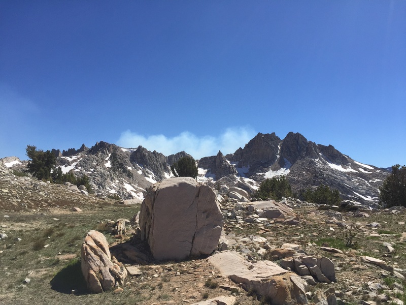
Well then. Thanks, imagination. Everyone laughs and starts passing the register around to sign. I cook some pho for lunch because I have nothing better to do, and then join everyone else as they head off, one-by-one. My mom stays at the lake for a while longer. I hike barefoot for a while, which phases the PCTers passing by, until my mom catches up. I put my sandals on. We skirt a slippery patch of snow and then we're on top of Silver Pass. A haze that we had noticed coming up to the pass becomes a veil of smoke smudging the view of the entire valley ahead of us. No one heading north seems to have much information about the smoke other than it's near Vermillion Valley Resort (VVR) and it's controlled, so it's probably not an issue. We get info from a PCTer about ferry times so we can get across Lake Thomas Edison to VVR, since we're more than a day ahead and need to kill time.
It's a quick drop down from Silver Pass, and we pass lakes in the haze as the sun is sinking. We want to get to the ferry in time so we don't have to walk, which means we need to be within 2-3 miles of it. We hit Pocket Meadow and there are a lot of people camped here, so I give my mom the only tent site and set up my sleeping bag to try cowboy camping. I really want to try it. My nose starts bleeding randomly as I'm getting ready to sleep and won't stop, which happens frequently up here because of the altitude and since it's so dry. It's best not to blow your nose, or even look at it the wrong way.
The mosquitos come. I get into my sleeping bag with the hood cinched tight and my headnet on. My nose begins bleeding again in earnest and my wad of TP is getting soaked with blood and the mosquitos are barraging my headnet and buzzing, buzzing, buzzing in my ear. I jump out and start pacing around barefoot. Between my wool sleeping clothes and mosquito bites and the actual mosquitos, I itch everywhere. My mom clears space in her tent and I dive in, 20 mosquitos with me. We sit and talk until it's dark enough for the mosquitos to have gone.
I clamber out and into my beautiful cozy soft silken sleeping bag, a couple of the more persistent mosquitos still bumping into my headnet. Pines skew haphazardly across my field of vision. I wake up in the middle of the night and see the stars.

Day 4, July 13th: Red's Meadow Resort to Duck Pass Trail Junction. 10.8 miles. (Note: these entries are from my trip last summer. I am writing them after-the-fact)
We sleep in, and as usual I wake up to my mom getting ready for the day. It's a huge cabin, with a full kitchen and 5 or so beds, half of them in an upstairs room. It feels weird to have it to ourselves. Our packs sit by the couch, still mostly packed from yesterday. Gritty trail dust forms a film over the floor near our trail shoes, gaiters lying limply beside them. We decide not to bother with the washing machines down near the store and rinse some of our clothes in the sink, leaving them to dry on our trekking poles stretched across two chairs. They're not really that dirty yet, especially since there is so much water along this trail and we swam at Thousand Island Lake the other day. I follow my mom down for breakfast at the café in my rain and sleeping clothes. Eggs, sausage, and bacon. This hike has been luxurious so far.
The café is full and the open area between all of the buildings is scattered with hikers fiddling with their packs, few of them showing motivation to leave. We talk with a few, a PCTer named Mover who hikes every year and knows Billy Goat, and a JMTer named Kapiko from Hawaii. They offer my mom encouragement and advice to HYOH after the hard moments in the heat yesterday.
Finally, after dilly-dallying quite a bit more, we get moving at 10:20; late by hiker standards. The first mile after Red's the trees are once again snapped in half, or uprooted completely, and littered across what was once the forest floor. We wade through ferns that tower almost to our waists. We meet a hiker named Robert, who is carrying three bear cans and a month's worth of food, hiking from lake to lake and fishing. He explains that there was a huge, sudden windstorm that swept through the Sierra a few winters back and caused huge swathes of trees to snap off. It was a combination of incredible wind speeds and the fact that the wind came from the opposite direction than normal, where the trees didn't have root systems to support them. (I find evidence of this event as far south as Kearsarge Pass. Without Google to corroborate, this explanation was as good as any and as far as I've researched it seems true).
The rest of the day is a steady uphill along dry and sandy ridges. Good cell service continues well past Red Cone, a volcanic-looking red and conical mountain. PCTers pass us, including a group that have dirty dreadlocks down to their waists and are gray with a film of dirt and grime. I think they must be stoned, although I'm not even sure what that looks like, because they don't react or even blink to my hello as they stumble past me. They're the first I've met that smell bad (I disagree that thruhikers really "stink". They just smell human).
We pass a group of JMTers, including a girl who just got Altras at Mammoth Lakes (Red's) to replace a pair of problematic boots. She's excited that I have a pair, too, and calls me her sole sister.
I'm sorry if these entries are all just about the people I meet and interactions; the JMT truly is a social trail.
We find a campsite by a creek near the Duck Pass Trail junction and decide to stop here, instead of pushing up an elevation rise to Purple Lake. We eat Mac n Cheese, and I add a sweet and spicy tuna packet that I was gifted in Tuolumne. I wish I would have just eaten the tuna by itself as it loses its flavor in the watery noodles.
My "sole sister" and the rest of the big group she's with camp on a rise across from us. They've brought a red hammock and it hangs between two pine. I go down to the creek to filter water and sing Christmas songs to pass my least favorite chore. The sun is below the ridge and the light is turning grey. I sit in the meadow on a rock and try to write in my journal, but there are mosquitos and instead of writing I catch them to press between my journal pages like flowers.
I go to bed to end the buzzing and biting. I'm cozy and I turn my phone volume down as low as it will go, set it by my ear inside my sleeping bag, and listen to Lullabye by Billy Joel on repeat. My dad used to sing it to me and my brother when we were upset, and it's soothing. I love the symmetrical and geometric ridgeline of my tarp-tent, the way it sways gently when the wind runs over it. How the moon makes it bright inside and casts shadows. The rustle of the wind and my mom as she turns over in her air mattress. I tell my tent in my mind how much I love it, euphoric, thoughts running through my mind like a creek over stones. I need to go to bed though, my legs throb anc are tired.
I get up to pee, crouching barefoot behind a bush willow, hidden by the dark. I stand by the entrance to my tent, reluctant to get back in. A PCTer cowboy camps in the meadow below us, cooking in his sleeping bag by the light of his headlamp. The fading light of the sky, stars fading in, and his headlight beam moving back and forth are the only light. I stand barefoot in the dark, breathing silently. I love this place, I love being here, I don't want it to end. I let the mountain cold sink into my body, the cold, sharp, earthy smell of it clinging to my skin. I stay there for a while, watching the meadow and the stars.
Finally I give in and crawl into my tent. It's a long and gradual while before I fall asleep.
Amelia on Tue Jul 12, 2016 @ 10:09
- JMT Thru-Hike 2016
- Red's Meadow Resort

Day 3, July 12th: Garnet Lake to Red's Meadow Resort. 14 miles. (Note: these entries are from my trip last summer. I am writing them after-the-fact)
I wake up to the sound of my mom moving around camp. I closed the vestibule near my tent entrance last night because we're camped next to other people, and now condensation is frozen to the inside walls. It's melting and covering my sleeping bag with droplets where the warm bag has brushed against the drooping silnylon. I do my best to brush it off with my handkerchief and wiggle outside. My bear can is frozen shut and I hurt the cold tips of my fingers against the frost when trying to open it. It takes a while for my mom and I to pack up. We eat our cold breakfast and go down to the lake to dip our dirty water bags into the frigid, lapping water. It had been slapping against the rocks along the shore all night, sounding like voices or the filling up of water bottles.
I've been feeling really good hiking-wise, but because of that also mildly impatient with having to compromise on where we stop each day. I want to go further, always a little further. even though I know that we're going at the right pace. Most of this probably stems from the fact that I dislike the camping part of backpacking and would minimize it as much as possible. I don't like sitting around camp, and having to unpack and repack my possessions each day, and doing all of the little camp chores that seem to take up so much time.
I express this to my mom, and I can immediately tell that I've upset her. Even though she's doing well on this hike, it's still harder for her than me, and I feel horrible and awkward. She goes to filter another bag of water by the lake and doesn't talk to me.
When we start hiking the tension has mostly dissipated. We cross the outlet of the lake on a high footbridge, the water streaming in glittering, sinewy rivulets across the granite. I talk to a group of JMTers who are also from Reno and then pass them, following the trail up tight switchbacks up the side of the ridge bordering the lake.
My mom hikes fast in the mornings, and so it's the time when we hike the closest together, up the ridge still in shadow, the sun not yet high enough to reach us here. We crest a small saddle between granite ledges and down a small gully.
I stop to go off trail to pee while my mom goes ahead. When I come back to my pack the guy and his friend I met near Donahue come down the trail. They say hello and hike on. We end up leapfrogging them the rest of the day.
After a quick elevation rise near Shadow Lake, the rest of the day looks like it's all downhill. There's a worrying dark patch of compressed switchback squiggles on the map that corresponds with the Shadow Lake elevation change, however. Shadow Lake itself is shallow and silty around the shore, with the skeletons of pine trunks toppled into the water. I pause before turning into the first switchback.
The trees are dense here, and before too long the lake shore is receding between tree trunks far below me. My mom follows a half switchback behind me, and I wave whenever I pass her going the opposite way. At first I stop to catch my breath, but soon decide to try and get this ridge out of the way. My mom falls one, two, four zigzags below me. "How'd you get so far ahead?!" she calls, and I send a shrug. "I'm getting to the top without stopping. It must be close," I shout back. I can't see the lake anymore- nothing but trees and an endless brown slope of pine duff stretching up and down.
It must be close, I think. But it's not. I trundle up, using my legs to lever my body forwards, upwards. After what seems like forever I finally reach the top to find the guys we've been leapfrogging with sitting there. "That was a ridiculously long climb," I say. We start talking. Their names are Tanka and Bebak and they're originally from Nepal, but they've been working in Germany as doctors. No wonder their accents seemed so familiar; my grandparents hiked extensively in Nepal and have always had Nepali friends visiting them in the States.
They hike on and my mom and I follow, into an equally interminable downhill. It's hot, sandy and dusty, through an area that looks like it might have been burnt except that the trees are still whole, scattered intact like behemoth toothpicks across the forest floor. No shade. I fall behind and am out of water, and start tracking my mom's footprints in the dusty trail. The bottom of my feet ache. I catch up to my mom and we shuffle down the dusty and steep trail.
Where the JMT rejoins the PCT a PCTer with a smiling plush flower wrapped around his shouder strap, the kind you win at fairs, passes us. The first PCTer of the day; it's been odd to not have the steady stream of Nobo'rs passing us, beards, small packs, ear buds, and trail runners all blending their impressions into one in my mind.
We reach the boundary for Devil's Postpile National Monument, and cross a bridge over a river. We're both out of water, but with only 2 miles to go until Red's Meadow and the cafe there, we decide not to stop. Immediately we enter into a maze of paths, none of them marked for either the JMT or PCT. We stop a ranger and ask how to get to Red's on the JMT, and she cheerily points us forward, telling us to make a side trip to a waterfall. We pass under Devil's Postpile, which is an interesting geometric rock formation, but definitely NOT where we're supposed to be, as it's a side trip we had decided to pass on. Clean tourist people in hiking boots and t-shirts stare at us as we pass through. After climbing up a ridiculously steep hill we finally decide to turn around and go back to the bridge. I try to stay positive but we're both tired and irritated.
We find the PCT where it inconspicuously turns right up a slope. My mom is miserable in the heat and wants to continue without stopping for water. "No," I say, "go down to the river and let's filter some water."
We filter a liter each and then go. The trail is littered with horse manure and churned up until it resembles beach sand. It's just as difficult to walk on and the sand starts sifting into the mesh of my shoes until it collects just beneath the arch of my foot. We reach a road, and I'm not sure if that is the way up to Red's or if it's further up the trail. My mom sits down and starts crying. We agree for her to wait there while I check out the road. I pass some people with a screeching toddler, see the sign for Red's Meadow Resort, and call for my mom to follow.
It's early in the afternoon, the hottest part of the day, and I stumble around, sweaty and disorientated, to find somewhere safe to leave my pack. When it's off I feel light and airy, adding to my dream-state. My mom has disappeared, and when I find her in the store, she's just bargained with the cashier to get one of the A-frame cottages for half the price. I get a chocolate ice-cream bar that's dipped in chocolate, then peanut butter and then chocolate again, and eat it as I follow my mom to our cabin.
I take my shower second, rubbing my legs in attempt to get the layer of dirt off, but it still clings in little dots to my pores. We go over to the cafe and get burgers, chips and potato salad. Then top it off with more ice cream. Tanka and Bebak come in and sit with us, beers in hand, and we talk.
More talking, sitting around in a tired daze, and then sleep.
Amelia on Mon Jul 11, 2016 @ 09:41
- JMT Thru-Hike 2016
- Garnet Lake

Day 2, July 11th: Just before Lyell Fork to Garnet Lake. 11 miles (Note: these entries are from my trip last summer. I am writing them after-the-fact)
We wake up early and head out, but not early by PCTer standards as attested to by their steady passing, trekking poles clicking against rocks. The trail is forested, and joins the Tuolumne again as we pass through patches of Red Heather with its bright pink flowers and bristly, pine-needle-esque stalks poking up from the pine duff. We cross the river on a wood footbridge and begin rising out of the trees. The trail winds around small ridges of granite and alpine green, crossing more water, until we come out into what might be Maclure Creek. The creek is wide here, creating a tarn further up into the meadow. People are waiting to ford the river, fiddling with water shoes. After agonizing over the chore of taking my gaiters and shoes off, I step into the water. At first it is just cold, but as I stride in to my calves it begins to numb. I hobble over the loose rocks on the bottom, their smooth surfaces painful on my cold feet, and clamber up onto the soft trail.
I walk barefoot for a while to let my feet dry, when suddenly the mosquitos hit me. Why weren't they on the other side of the river? I find my headnet and struggle to put my toe socks on damp feet. Fortunately, the trail climbs quickly out of the narrow meadow, water rivulets sliding across the rough granite steps. Within five minutes I can put my headnet away. That wasn't so bad, I tell myself.
I'm fast on the uphill and get ahead of my mom. I hike near another guy who is waiting for his hiking partner to catch up. He's not American, but I can't place his accent from the couple of short exchanges we have. It sounds very familiar.
We have to cross a small snowfield as we climb up to Donahue Pass. The snow is still hard so it's slippery, and I have to screw my eyes shut against the light bouncing off of it. I probably should have brought sunglasses, even though I don't like them. I reach the top of Donahue and look back the way we came. Lyell Canyon is a small, bright strip of green between the rows of mountains. My mom comes and we pause to look at the clear pools of water that sit by the side of the trail. We say hello to the female ranger who is checking permits and head down the other side with a bunch of other hikers.
The mosquitos come. They come slowly so you think you can manage it, until suddenly you can't.
The response of the other hikers is to hike faster, and they quickly disappear down the trail until it is just me and my mom. While I'm fast on the uphill, I'm pretty slow on the downhill, where I'm careful to not slip or pound my feet or knees. For a while I try to outhike the mosquitos, try to move fast enough that they can't land, but they still buzz around my head in a cloud and get into my headnet. I hit my trekking poles against my ankles, swat at my legs and wrists. My headnet is hot and is making it hard to breath. Finally I stop and find my windpants, tugging them on over my shoes. Now the only thing that isn't covered are my hands, and even though I have to go slow not to overheat, it suddenly becomes almost bearable. I still want to melt into a puddle, but not nearly as fervently.
It's gorgeous on this side of the pass, bright green tussocks and clumps of small, twisted pine, with pools of mosquito-incubating water riddling it all like Orthanc after the Ents. I feel bad that I've missed it with the mosquitos, but oh well.
The trail descends from the mosquito swamplands and suddenly there is a breeze. I take my headnet off and pause to breath and wait for my mom to catch up. A PCTer comes up and I lament to her about the mosquitos. "What mosquitos?" she asks. "The mosquitos aren't bad at all."
"They're pretty bad," I say, lamely, and she hikes on.
The trail immediately becomes arid and the soil sandy as it descends to what the map euphemistically calls "Island Pass," and I imagine that the PCTer learned the truth of my words. We meet an awesome PCTer named Smiles when we are filtering water, who hiked the JMT solo when she was my age. We talk about hiking the PCT solo and young and she says go for it. She is definitely my favorite thru-hiker we have met, very positive and friendly.
We pause at Thousand Island Lakes, which is very pretty but hardly the golden child of the JMT like people claim (at least that's what I think). The sun is getting low as we pass Ruby Lake, with dark cliffs plunging into the clear water, desolate scree piles hugging the base. We only stop for a moment, but Ruby Lake is one of the most understated and dramatic lakes that I will see on the trip.
We set up camp at Garnet Lake, with the classic view of Banner and Ritter Peaks reflecting off of the surface. It's 14 miles to Red's Meadow from here, all downhill, and we plan on eating real food for dinner tomorrow. My hands got a little burned, and like everyone else I've noticed that I'm getting tanner on my right side faster than on my left, since we're walking south.
Amelia on Sun Jul 10, 2016 @ 07:55
- JMT Thru-Hike 2016
- Lyell Canyon
Day 1, July 10th: Tuolumne Meadows to just before Lyell Fork. 10.9 miles (Note: these entries are from my trip last summer. I am writing them after-the-fact)
I wake up around 7 or 8 to the sound of my mom taking down her tent. I pull my sleeping clothes off and dress- awkward in such a low tent- and poke my head outside. Mom's tent is opposite me, our entrances facing each other, and she bustles around it, folding the tent poles. "Good Morning," I murmur to her, my face still warm from sleeping. The people that set their tent up next to me last night are a ways off to the right. It's quiet compared to last night, with only a few sleepy people awake and boiling water for coffee or oatmeal. The smell of dead campfires is heavy in the nippy air. I wriggle out, shove my feet in my shoes. I pull my foam pad out with everything on it and start to pack up; we have to be at the permit office by 10:30 or we lose our permit.
I'm slow, but finally everything is in my backpack in more or less the right place. We stop to go to the bathroom one last time and go to meet Vicki and Barb at the Tuolumne Grill. I'm not hyper excited (it's too cold for that) but my mood is reflective. We're finally on our way, after months of planning, and I know all we have to do now is walk and make camp for a few weeks. The parking lot is empty, very different from how it was yesterday, and it's 15 minutes until the grill opens. I set my pack next to a rock by the main park road and stand on top of the rock, trying to get warmth from the sun. I brandish my trekking poles at passing cars. Here I come!
Cars start pulling in, right on cue, and we stand in front of the Grill doors to start a line. Vicki and Barb have to catch the YARTS bus down to Yosemite Valley, and after breakfast and a final phone charge the bus comes. We say goodbye and then start our walk to the permit office. We're already on the JMT, and we see a lot of backpackers. We cross over the Tuolumne river for the first time, which we'll follow all day. Lembert Dome dominates the view as we walk, a scalene triangle of dark-streaked Sierra granite. Mom's backpack, parrot-green, bobs up and down as she walks, her Platypus hose swaying loose in the air. It's all so beautiful. This national parks thing being gorgeous is no practical joke, I think as we walk. On the right is a golden meadow and on the left is Tioga Pass Road. The sun shines bright over everything.
We get to the permit station. People are camped outside in a line with folding chairs and warm clothes, their breath puffing up in clouds. They're waiting for walk-up permits, probably for the John Muir Trail, and I feel guilty as we walk past them and squeeze inside. The ranger, a woman, gives us the talk and issues us a permit and wag bags for Whitney. We have to carry them the whole way. We pause at the picnic table to apply sunscreen and remove the extra TP and hand wipes from the wag bags.
Finally we get out of there, passing a couple that just got their permit and were laying their resupply out in the parking lot. "See you out there, maybe!" we say. The trail goes along the road a bit more, and then heads off into a dry granite-and-meadow-strewn forest. Tons of PCTers pass us, not wanting to chat, eager for real food. The trail isn't that impressive: dry, littered with toilet paper, and full of grumpy weekenders with heavy boots and even heavier packs. It reaches the Tuolumne River again and we cross a series of foot bridges. The water runs between banks of granite, quick and smooth and incredibly hued: green and blue and golden-brown. We pass a ranger who's out leading a wildflower identifying trip, and say hi. Our maps are still buried in the middle of our packs when we come to our first unmarked junction.
We start heading down what we think is the right trail, but we double back to look at the posted map near the junction with a couple of other JMTers. The ranger comes by and my mom asks, "That way is the right trail, right? We're on the JMT."
He sighs, and walks over to the map. "If you're on the JMT, you have to follow this trail. You go down Lyell Canyon for a day or two and eventually you go over Donahue Pass, right here, see?" I stare at my mom in disbelief. We know where we are going!
"Yah, we know. We just want to know if that's the right trail." My mom points the way we were going.
The ranger keeps on talking. "You have maps, right? Maybe if you're already lost you shouldn't be hiking the JMT." My mom and I move away in disgust. The ranger freaks out. "No! That's the wrong trail. It's that way." He points to the one we were just going down a few minutes before.
"We know," she says to him, and says to the guys who were looking at the map with us, "You know what mansplaining is, right?" The guys had been just as "lost" as we were. We start walking down the trail, and I'm angry for the next hour or so as we walk. The terrain is flat, more of the same dry meadows and small pine patches. I would be tempted to call it ugly, but I know it's my state of mind and nothing else.
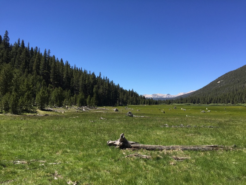
As we reach Lyell Canyon proper, the tense feeling in my stomach fades. The trail follows the edge of a pale-green meadow full of purple daisies, the Tuolumne River a bright twisting stripe of turquoise winding through it. Rows of mountains march away on either side, chaotic, behemoth tumbles of granite with bases swallowed by green. There are dozens of little ground squirrels and their babies running around, and marmots. They seem too cute for their evil reputation. And Lyell Canyon is too beautiful and kind for me to believe its reputation for trouble bears. Amelia Earhart Peak is somewhere on the right, and I take a selfie with a mountain that I think is it, but later find out isn't. We share a namesake, and so I feel like the mountain and I share a kinship.
We come upon Audrey, a woman that we met last night at the backpacker's campground, and stop to talk and admire an especially bright-blue bend of the river. She says that she's from Chicago, and that she's been struggling already. We've only come maybe three miles so far, and she started a few hours earlier than us. Her pack is huge, taller than her waist when she puts it on the ground. She says its shoulder straps have been cutting into her shoulder. I ask about the rusted-steel garden trowel hanging from the outside, with a wooden handle. "My husband cut the handle in half for me to save weight," she says. We give her encouragement and reassure her it's okay to take it slow the first few days, and then head off. We leapfrog her for a bit when we take lunch, and the last I see of her is her resting down by the river under a patch of pine. I hope she makes it at least to Red's Meadow.
We spend the rest of the day walking through flat Lyell Canyon. There's a nice breeze, and no mosquitos. It really is a perfect, idyllic day of hiking, and although we contemplate the river we really smell too nice to justify getting in. We reach the end of the canyon as the sun is getting low and bright above the mountains, and begin an ascent. "Maybe we can get over Donahue tonight," I say, thinking that this was the beginning of the pass. Tons of PCTers are coming down, and when we ask they shrug and tell us it's ten minutes to the top. There's a Korean couple that just bursts into laughter when we try to communicate to them in English, and a British guy who hikes in a formal tie. We reach a spot with a nice camp spot, and decide to stop for dinner and maybe go on after. We have Good-to-Go Pad Thai, which is fine but even finer when you're hungry, and we pass the foil bag back and forth to avoid dishes. Mom makes the executive decision to stay here for the night, so we set up our tents and then walk to a granite overhang to watch the alpenglow slide up the mountains. We listen to the birds sing and write in our journals. Finally it gets too cold and I snuggle in my warm sleeping bag for the night.
It was a good day.
JMT Thru-Hike 2016
- Amelia
- updated Jul 12, 2017

- 12 Entries
- 2 Followers
- Backpacking
Outsideways Blog
Journal Spotlight: Kayaking Around the Eye of Quebec

One of our members, will soon be circumnavigating one of the coolest lakes in Quebec by kayak