Day 1, July 10th: Tuolumne Meadows to just before Lyell Fork. 10.9 miles
(Note: these entries are from my trip last summer. I am writing them after-the-fact)
I wake up around 7 or 8 to the sound of my mom taking down her tent. I pull my sleeping clothes off and dress- awkward in such a low tent- and poke my head outside. Mom's tent is opposite me, our entrances facing each other, and she bustles around it, folding the tent poles. "Good Morning," I murmur to her, my face still warm from sleeping. The people that set their tent up next to me last night are a ways off to the right. It's quiet compared to last night, with only a few sleepy people awake and boiling water for coffee or oatmeal. The smell of dead campfires is heavy in the nippy air. I wriggle out, shove my feet in my shoes. I pull my foam pad out with everything on it and start to pack up; we have to be at the permit office by 10:30 or we lose our permit.
I'm slow, but finally everything is in my backpack in more or less the right place. We stop to go to the bathroom one last time and go to meet Vicki and Barb at the Tuolumne Grill. I'm not hyper excited (it's too cold for that) but my mood is reflective. We're finally on our way, after months of planning, and I know all we have to do now is walk and make camp for a few weeks. The parking lot is empty, very different from how it was yesterday, and it's 15 minutes until the grill opens. I set my pack next to a rock by the main park road and stand on top of the rock, trying to get warmth from the sun. I brandish my trekking poles at passing cars. Here I come!
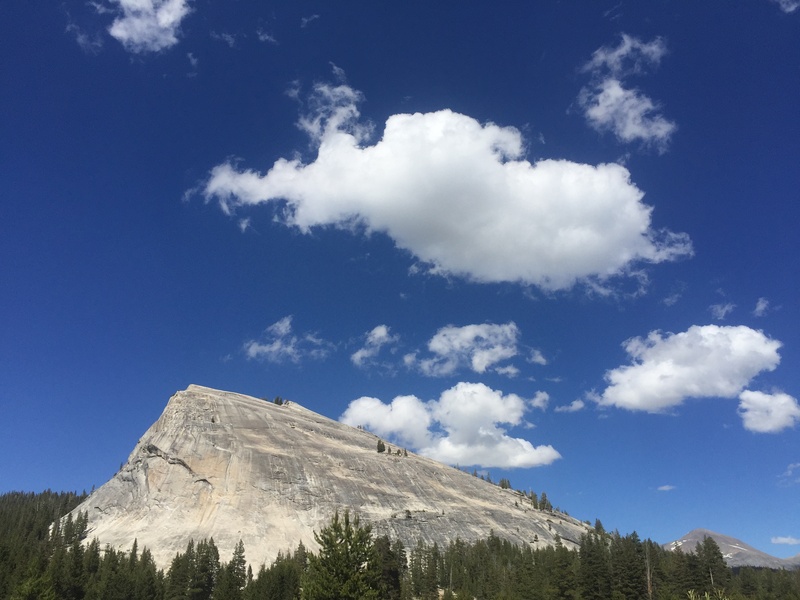
Cars start pulling in, right on cue, and we stand in front of the Grill doors to start a line. Vicki and Barb have to catch the YARTS bus down to Yosemite Valley, and after breakfast and a final phone charge the bus comes. We say goodbye and then start our walk to the permit office. We're already on the JMT, and we see a lot of backpackers. We cross over the Tuolumne river for the first time, which we'll follow all day. Lembert Dome dominates the view as we walk, a scalene triangle of dark-streaked Sierra granite. Mom's backpack, parrot-green, bobs up and down as she walks, her Platypus hose swaying loose in the air. It's all so beautiful. This national parks thing being gorgeous is no practical joke, I think as we walk. On the right is a golden meadow and on the left is Tioga Pass Road. The sun shines bright over everything.
We get to the permit station. People are camped outside in a line with folding chairs and warm clothes, their breath puffing up in clouds. They're waiting for walk-up permits, probably for the John Muir Trail, and I feel guilty as we walk past them and squeeze inside. The ranger, a woman, gives us the talk and issues us a permit and wag bags for Whitney. We have to carry them the whole way. We pause at the picnic table to apply sunscreen and remove the extra TP and hand wipes from the wag bags.
Finally we get out of there, passing a couple that just got their permit and were laying their resupply out in the parking lot. "See you out there, maybe!" we say. The trail goes along the road a bit more, and then heads off into a dry granite-and-meadow-strewn forest. Tons of PCTers pass us, not wanting to chat, eager for real food. The trail isn't that impressive: dry, littered with toilet paper, and full of grumpy weekenders with heavy boots and even heavier packs. It reaches the Tuolumne River again and we cross a series of foot bridges. The water runs between banks of granite, quick and smooth and incredibly hued: green and blue and golden-brown. We pass a ranger who's out leading a wildflower identifying trip, and say hi. Our maps are still buried in the middle of our packs when we come to our first unmarked junction.
We start heading down what we think is the right trail, but we double back to look at the posted map near the junction with a couple of other JMTers. The ranger comes by and my mom asks, "That way is the right trail, right? We're on the JMT."
He sighs, and walks over to the map. "If you're on the JMT, you have to follow this trail. You go down Lyell Canyon for a day or two and eventually you go over Donahue Pass, right here, see?" I stare at my mom in disbelief. We know where we are going!
"Yah, we know. We just want to know if that's the right trail." My mom points the way we were going.
The ranger keeps on talking. "You have maps, right? Maybe if you're already lost you shouldn't be hiking the JMT." My mom and I move away in disgust. The ranger freaks out. "No! That's the wrong trail. It's that way." He points to the one we were just going down a few minutes before.
"We know," she says to him, and says to the guys who were looking at the map with us, "You know what mansplaining is, right?" The guys had been just as "lost" as we were. We start walking down the trail, and I'm angry for the next hour or so as we walk. The terrain is flat, more of the same dry meadows and small pine patches. I would be tempted to call it ugly, but I know it's my state of mind and nothing else.
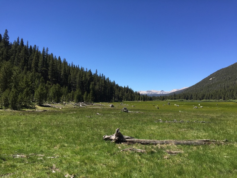
As we reach Lyell Canyon proper, the tense feeling in my stomach fades. The trail follows the edge of a pale-green meadow full of purple daisies, the Tuolumne River a bright twisting stripe of turquoise winding through it. Rows of mountains march away on either side, chaotic, behemoth tumbles of granite with bases swallowed by green. There are dozens of little ground squirrels and their babies running around, and marmots. They seem too cute for their evil reputation. And Lyell Canyon is too beautiful and kind for me to believe its reputation for trouble bears. Amelia Earhart Peak is somewhere on the right, and I take a selfie with a mountain that I think is it, but later find out isn't. We share a namesake, and so I feel like the mountain and I share a kinship.
We come upon Audrey, a woman that we met last night at the backpacker's campground, and stop to talk and admire an especially bright-blue bend of the river. She says that she's from Chicago, and that she's been struggling already. We've only come maybe three miles so far, and she started a few hours earlier than us. Her pack is huge, taller than her waist when she puts it on the ground. She says its shoulder straps have been cutting into her shoulder. I ask about the rusted-steel garden trowel hanging from the outside, with a wooden handle. "My husband cut the handle in half for me to save weight," she says. We give her encouragement and reassure her it's okay to take it slow the first few days, and then head off. We leapfrog her for a bit when we take lunch, and the last I see of her is her resting down by the river under a patch of pine. I hope she makes it at least to Red's Meadow.
We spend the rest of the day walking through flat Lyell Canyon. There's a nice breeze, and no mosquitos. It really is a perfect, idyllic day of hiking, and although we contemplate the river we really smell too nice to justify getting in. We reach the end of the canyon as the sun is getting low and bright above the mountains, and begin an ascent. "Maybe we can get over Donahue tonight," I say, thinking that this was the beginning of the pass. Tons of PCTers are coming down, and when we ask they shrug and tell us it's ten minutes to the top. There's a Korean couple that just bursts into laughter when we try to communicate to them in English, and a British guy who hikes in a formal tie. We reach a spot with a nice camp spot, and decide to stop for dinner and maybe go on after. We have Good-to-Go Pad Thai, which is fine but even finer when you're hungry, and we pass the foil bag back and forth to avoid dishes. Mom makes the executive decision to stay here for the night, so we set up our tents and then walk to a granite overhang to watch the alpenglow slide up the mountains. We listen to the birds sing and write in our journals. Finally it gets too cold and I snuggle in my warm sleeping bag for the night.
It was a good day.